
Comparing Google Earth’s graphics after nearly 20 years
Is Google Earth a game? I used to daydream about its satellite map data being used to turn our real world into video game raceways, but I never really thought about the service itself as a game. I’m not actually here to answer that question, it just wound up being a related thought as I realized how far its representation of the real world has come over the years.
I was just poking around in my old document folders and found this screenshot from July of 2005 when, if memory serves, they’d just started rolling out 3D buildings in Google Earth. No, it wasn’t so slow that it hadn’t loaded the textures yet, there simply weren’t any. Gray boxes were mind-blowing enough and that’s all we needed.
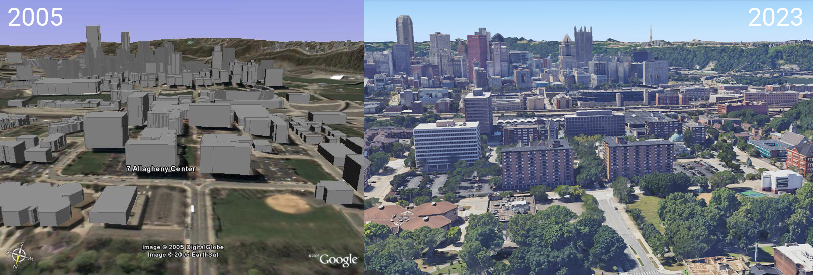
What’s even wilder was then remembering that much of the early 3D buildings were fan-created in modeling suites like SketchUp and Building Maker and handed over to Google for free as “community contributions”. I’m sure that’s all been replaced with more accurate photogrammetry but it’s crazy to think about fan contributions being at the core of what we all use nowadays to navigate the world.
Anyways, back to the graphics. Over nearly twenty years things have improved so incrementally that it’s almost impossible to remember what it was like without the side-by-side comparison here. What we see nowadays could easily pass the squint test. Go on, squint at it. The right side could pass for an everyday photograph where the former only becomes convincing after you’ve squinted your eyes shut and are now just picturing a landscape in your mind’s eye.
I’m so glad I decided to take a screenshot of this for myself. At the time I just thought it was cool to see my college apartment building recreated in a 3D space. All these years later it unexpectedly became a very personal anchor point in seeing how far our technology has come.
As for that opening thought, sure. Google Earth (or Maps) is a game. It’s interactive and I’ve definitely wasted a ton of time exploring its 3D globe over the years.
P.S. That’s downtown Pittsburgh, Pennsylvania where I went to college. In 2005 it was the only metropolitan area that I was familiar with that had 3D buildings on Google Earth. Just out of view at the bottom of the frame is a sidewalk that appeared in Kevin Smith’s Dogma which was being filmed while I was still there. Trivia!!